
Show labels for
General Options
Tags on label, track color based on, track visibility, playback speed.
SUPERYACHTS TRACKER
| Rank. YACHT NAME, Length x Width - Owner's Name | |
| 1. 220 x 20 m - Company "Quintessentially" | |
| 2. 180 x 20 m - Khalifa bin Zayed Al Nahyan | |
| 3. 163.5 x 22 m - Roman Abramovich | |
| 4. 162 x 22 m - Mohammed bin Rashid Al Maktoum | |
| 5. 155 x 24 m - Sultan Qaboos of Oman | |
| 6. 147 x 18 m - King Abdullah of Saudi Arabia | |
| 7. 147 x 21.5 m - Mansour bin Zayed Al Nahyan | |
| 8. 145.7 x 13 m - Arab Republic of Egypt | |
| 9. 141 x 15 m - Hamdan bin Zayed bin Sultan Al Nahyan | |
| 10. 140 m - Victor Rashnikov | |
| 11. 139 x 23.5 m - Crown Prince Sultan of Saudi Arabia | |
| 12. 138 x 19 m - David Geffen | |
| 13. 136 x 16 m - Republic of Turkey | |
| 14. 134 x 18.5 m - Yuri Scheffler | |
| 15. 133 x 20 m - Sheikh Hamad bin Jassim bin Jaber Al Thani | |
| 16. 126 x 21 m - Paul Allen | |
| 17. 123 m - n/a | |
| 18. 125 x 17 m - n/a | |
| 19. 124 x 20 m - Hamad bin Khalifa Al Thani | |
| 20. 122 x 17 m - Latsis family | |
| 21. 119 x 19 m - Andrey Melnichenko | |
| 22. 116 x 17 m - Latsis family | |
| 23. 116 x 14.5 m - Niarchos family | |
| 24. 116 x 14.5 m - n/a | |
| 25. 115 x 17 m - David Geffen | |
| 26. 115 x 20 m - Farkhad Akhmedov | |
| 27. 113 x 18 m - Eugene Shvidler | |
| 28. 110 x 16.5 m - Abdullah Al Futtaim | |
| 29. 110 x 16.5 m - Alisher Usmanov | |
| 30. 109.5 x 15 m - n/a | |
| 31. 105 x 19 m - Nasser al Rashid | |
| 32. 104 x 17 m - Sergey Galitskiy | |
| 33. 104 x 16 m - Sultan Qaboos | |
| 34. 101.5 x 14 m - n/a | |
| 35. 101 x 16 m - n/a | |
| 36. 100 x 13 m - Dennis Washington | |
| 37. 99 x 11 m - John Paul Papanicolaou | |
| 38. 99 x 13.5 m - Andrei Skoch | |
| 39. 97 x 16 m - Heidi Horten | |
| 40. 96 x 12.5 m - Leslie Wexner | |
| 41. 96 x 17.3m - Ernesto Bertarelli | |
| 42. 95 x 16.2 m - Mikhail Prokhorov | |
| 43. 95 x 14 m - n/a | |
| 44. 95 x 15 m - Vijay Mallya | |
| 45. 93 x 13.5 m - n/a | |
| 46. 92.5 x 14.3 m - n/a | |
| 47. 92.5 x 15 m - Paul Allen | |
| 48. 93 x 16 m - Alberto Bailleres | |
| 49. 91.5 x 14.5 m - Do Won Chang | |
| 50. 91.5 x 12 m - Sir James Dyson | |
| 51. 91 x 14.35 m - n/a | |
| 52. 90.6 x 15.3 m - Sheikh Hamdan Bin Mohammed AL Maktoum | |
| 53. 90 x 12 m - Neil Taylor | |
| 54. 90 x 15 m - Suleiman Kerimov | |
| 55. 90 x 12 m - n/a | |
| 56. 90 x 14.5 m - n/a | |
| 57. 88.5 x 14 m - n/a | |
| 58. 88.5 x 14 m - Vladimir Potanin | |
| 59. 88 x 21 m - Brian Chang / Vincent Tan | |
| 60. 88 x 12.6 m - n/a | |
| 61. 86 x 14 m - Majid al Futtaim | |
| 62. 88 x 14 m - Mark Cuban | |
| 63. 88 x 14 m - Larry Ellison | |
| 64. 87.5 x 14.7 m - James Packer | |
| 65. 90 x 14 m - Jan Kulczyk | |
| 66. 87m - n/a | |
| 67. 86 x 11.5 m - Khalifa bin Zayed Al Nahyan | |
| 68. 86 x 13 m - Alwaleed bin Talal | |
| 69. 86 x 14 m - Steven Spielberg | |
| 70. 86 x 14.5 m - n/a | |
| 71. 85.5 x 14 m - n/a | |
| 72. 85.6 x 14.3 m - ex Charles Gallagher | |
| 73. 85.5 x 14.2 m - Ravi Ruia | |
| 74. 85.5 x 14.2 m - Reinhold Wuerth | |
| 75. 85.3 x 14.5 m - Sheikh Sultan bin Khalifa Al Nahyan | |
| 76. 85.3 x 14.4 m - H.H. SH. Mansour bin Zayed Al Nahyan | |
| 77. 85.2 x 16 m - n/a | |
| 78. 85.1 x 13.8 m - n/a | |
| 79. 85.1 m - Yuriy Kosiuk | |
| 80. 83.5 x 12.5 m - n/a | |
| 81. 82.5 x 11.6 m - Paris Dragnis | |
| 82. 82.5 x 12.4 m - Nancy Walton | |
| 83. 81 m - Alexander Mamut | |
| 84. 82 x 11 m - n/a | |
| 85. 82 x 15 m - Fahd bin Sultan | |
| 86. 82 x 14.2 m - Theodore Angelopoulos | |
| 87. 82 x 13 m - Government of Iraq | |
| 88. 81.8 m - n/a | |
| 89. 81 x 12 m - Augusto Perfetti | |
| 90. 80.8 x 12.8 m - Arnie Gemino | |
| 91. 76 x 11.5 m - n/a | |
| 92. 80 x 12.8 m - Khalid bin Sultan | |
| 93. 80 x 13.5 m - n/a | |
| 94. 80 x 14.2 m - Lakshmi Mittal | |
| 95. 80 x 13 m - n/a | |
| 96. 80 x 13 m - n/a | |
| 97. 82.6 x 10.5 m - Sir Paul Getty | |
| 98. 79 x 12.4 m - n/a | |
| 99. 78.7 x 11.3 m - Saudi royal family | |
| 100. 77 x 12.9 m - Ron Tutor | |
| 101. 78.5 x 12.7 m - n/a | |
| 102. 78.5 x 13.8 m - Emilio Fernando Azcarraga Jean | |
| 104. 105 x 16 m - Oleg Burlakov | |
| 103. 136 x 21 m - Undisclosed |
- Privacy Policy
- Terms of Use
20 emails/day
Send 0 emails out of 20 today
- Home
- Terms of Use
Satellite AIS
Monitor the global picture of the world maritime traffic.

Prices do not include VAT
Satellite AIS is the only source of up-to-date ship positions data in the most remote areas of the world, especially in the open oceans and beyond the reach of terrestrial AIS systems.
Combining data received via Satellite AIS technology and data from thousands of Terrestrial AIS stations, we deliver the most complete picture of global vessels activity.
Every ship position is regularly updated via Satellites, typically from a few minutes to several hours. On an average basis, 90% of all ship positions are with a latency less than 1 hour.
For more information or an alternative payment method, feel free to contact us .
In A Historic First, 2 Chinese Container Ships Cross Paths Just 75 Nautical Miles From The North Pole

MSC Competes with Maersk For Denmark’s Largest Container Port of Aarhus

Watch: Cruise Ship Collides With Large Piece Of Drifting Ice In Alaska

Canadian Coast Guard Acquires Its First-Ever Autonomous Surface Vessel

Top 15 Ship Tracking Websites To Find Your Ship Accurately
The rapid advancement of technology has significantly improved monitoring and tracking of ships recently. In addition, the fast-developing satellite services have made ship tracking across the globe easier now, thus ensuring the safety of vessels from various threats.
With the help of satellite-based vessel monitoring systems (VMS), different types of vessels have been 3. Shipfinder is monitored efficiently by marine agencies and vessel owners for a long period.
The automatic identification system (AIS) helps track bigger vessels crossing waters worldwide by offering real-time information about the vessels.
Currently, several websites provide ship tracking using the automatic identification system to display the real-time location of the ships.
With the help of transponders equipped on the vessels, the satellites will collect AIS signals from the vessels to provide their position, route, speed, and ship type through various online platforms.
Moreover, the introduction of Google Earth has revolutionized ship tracking, allowing access to every detail of almost all ships within seconds.
However, since various online services provide vessel tracking information, the purpose of the content provided varies.
It is important to note that ship tracking through these online platforms is often meant for educational purposes.
However, many of these services are also used to track different types of cargo ships, such as container ships .
Though most of these service providers promise a “real-time” location of the ships, the data displayed is always behind by a few minutes or even several hours. Thus, this information should NEVER be used for navigation purposes .
Here, we list a few prominent websites widely used for near-accurate online ship tracking.
These vessel trackers provide the ship’s location, technical and non-technical details, designated routes, and photographs.
Notable Vessel Tracking Websites
1. marine traffic .
Marine Traffic, one of the most famous and widely used online ship tracking systems, offers ships’ real-time data and advanced search features.
It offers vessel owners many services, including satellite AIS coverage, enhanced satellite tracking, advanced density maps, nautical charts, etc.
Apart from tracking ships, Marine-Traffic also allows the tracking of various Ports around the world. Moreover, the AIS system of the website boasts a massive database of ships of every type.
Marine traffic records at least 800 million vessel positions and 18 million vessel and port related events monthly. In addition, it offers information about 650000 marine assets such as vessels, ports, lights, etc.
This open, community-based project offers many services free of cost, while more advanced functions come with a fee.
The website operates more than 2000 AIS stations located in over 165 countries and has over 600,000 registered users and around 20 million visits to its website every month.
2. FleetMon
FleetMon, another open database of ships and ports worldwide, offers real-time AIS position data of ships, along with technical information on over 500000 vessels.
It provides the vessel’s particulars, schedules and port arrivals, trading patterns and photos according to the customer’s search.
Using its interactive tool FleetMon Explorer, you can see a real-time view of the marine traffic and access information on operations monitoring, logistics scheduling, fleet tracking, traffic analysis, etc.
Established in 2007, FleetMon currently has customers across 164 countries. Fleet Mon is one of the finest ship tracking services, offering iPhone and iPad apps.
3. Shipfinder
This is another widely used ship tracking service online that allows one to find ships through various options such as ship number, tonnage, capacity, ownership, construction, etc.
This online service collects AIS ship feeds used by vessels over 300 tonnes, passenger vessels and small vessels like yachts to provide real-time information to its customers.
It also keeps track of the user’s search history to provide a better user experience and offers premium paid membership for advanced users.
4. VesselFinder
Established in 2011, VesselFinder offers real-time data on more than 100,000 vessels daily with the help of a large network of terrestrial AIS receivers.
Offering services across digital, social and mobile platforms, VesselFinder offers efficient monitoring services, port calls, master data and a detailed voyage history of each ship. In addition, it also provides historical AIS Data services that deliver customized ship movement reports, analysis of traffic density and video simulation of vessel movements, among others.
5. Vesseltracker
With a database of more than 1,000,000 vessels, Vesseltracker provides customized real-time and historical data on vessels voyaging worldwide. It helps users monitor vessels with the help of map views and layers, including Google Satellite, Google Earth, nautical charts, etc.
The website has a huge database comprising updated vessel specifications, characteristics, ownership and management information, etc. In addition, Vesseltracker offers analytics and reports on vessel movements and port events.
6. VT Explorer
VT Explorer offers users real-time AIS position data and technical information of more than 100,000 ships daily. Apart from the required information, the website also provides images of all the vessels being tracked.
Available to use from both your personal computer and mobile, VT Explorer helps monitor ship schedules and arrivals to analyze trading patterns.
7. myshiptracking
myshiptracking is another advanced website that provides real-time positions of vessels worldwide. With its large database, myshiptracking allows users to monitor vessels and ports efficiently to analyze marine traffic worldwide. The website also allows you to save your browsing data and offers its service to iPhone and Android users through mobile apps.
8. Cruisemapper
Unlike other online vessel monitoring websites, CruiseMapper offers information on the positions and schedules of cruise ships serving tourists worldwide.
With its Cruise ships and ports database, the website provides information on each cruise’s features and technical specifications and information for major ports that house the cruise ships.
9. Ship location
On the ship location website, one can track 80,000 sea and river-going vessels, know the status of 17,000 ports and marinas, 1400 cruise ports, 1000 shipyards and much more.
It is designed for ship owners, managers, logistics companies and agencies. Even individuals can use it for ship tracking.
The website has three useful maritime tools-
- Distance calculator- for calculating port-to-port distance via different routes.
- Maritime locator- which helps in tracking ship-related services
- Ship tracker- helps in tracking ships using geographical coordinates
Among all, the maritime locator and the ship tracker are immensely useful. The locator saves time by allowing a person to search for the closest commercial or cruise ports or shipping services, such as repair yards, ship agencies, bunkers, etc.
10. Baltic Shipping
Baltic Shipping strives to maintain the world’s most advanced seafarers database. All the professionals in the shipping industry can use this website. Individuals can develop their careers and find new job openings from reputed maritime companies.
It allows people to keep all the documents in one place, and they can be easily shared with the companies. One can also monitor the expiration date of the documents, and the system will keep everything updated automatically. The registration is also very simple.
Another important service provided by the website is vessel tracking and vessel search. It has a huge database for different vessels. You can get information about that particular vessel by putting in the vessel’s name, IMO number and vessel type.
11. Alltrack
Alltrack allows one to search for a ship by its name/ IMO/MMI number. One can also scroll down and choose from the elaborate database directly. One can track their vessels or ships live and see the ports on the map. Hence, it offers live ship tracking free.
The website is user-friendly and has a simple interface. It also offers other services like air cargo tracking, postal tracking, and courier tracking and provides tracking links.
12. Marine vessel traffic
This website offers many services. It has around 112,000 ships in its database and information about more than 1000 shipyards, allowing vessel tracking by name.
The website does not use its tracking technology but integrates Vesselfinder and Marine traffic on its platform. It’s a great idea; one can find all vessel-related information anywhere.
Also, there is a fleet list of major cruising companies, and the fare discounts offered. One can book their cruise ship tickets here as well. Since COVID-19 hit, the website also shows the names of ships infected with COVID-19.
The website also has tools like a plane tracker, distance calculators, IMPA Codes, air cargo tracker, baltic dry index, nautical charts, incoterms, weather tracker, etc.
13. Marine Online
Marine Online is an e-commerce company based in Singapore that offers important marine-related services to shipowners. It has a website as well that allows for vessel tracking and provides services like vessel karting, ship supply, crewing, marine insurance, bunkering, etc.
This website provides access to basic and advanced container ship tracking information free of charge. Data fields such as vessel, route info, estimated time of arrival, and next port of call are available at the tip of your fingers.
Registered customers can also access the fleet management function and charter info like contacts of operators and technical managers. However, it is important to know that most tracking data is free of charge.
14. Datalastic
This website allows real-time vessel tracking and monitoring. One can access information on all vessels worldwide without any geographical limitations.
The website is not free, and one can choose from the given plans- Starter, Experimenter and Developer Pro+.
The website’s Live ships tracking REST API allows one to access vessel data like the ship’s location, estimated arrival time, deadweight tonnage, navigational status, destination, etc.
One can put in the MMSI number of the vessel for tracing it, or one can specify the type of vessel one needs to track and give additional info like gross tonnage of the ship, its name, etc., to get quick results.
The ship tracker tool has a profound database comprising 36 vessel types and over 300 subtypes.
What makes AISHub different from other vessel tracking websites is access to the raw AIS feeds. The aim of this website is to be a raw NMEA AIS data-sharing centre and a valuable reservoir of data for all individuals and professionals interested in developing AIS-related software.
The website has a map and a tracker showing the number and location of the vessels plying in the world. One can click on a country or region and get the status of the number of vessels there.
Ship-tracking websites have drastically changed how ships and consignments are tracked, and marine traffic is monitored. These websites offer a wealth of information with just one click, allowing us to see the vessel’s position in real-time. One can easily get access to the up-to-date and latest info on the ship’s movement, current location, speed and direction.
These websites enable us to track ships across the globe, which is important for businesses involved in shipping and providers of shipping services.
Whether you are a maritime professional, a ship enthusiast, or someone who likes to track maritime traffic, ship-tracking websites are important tools that allow you to get all the information about a particular ship or even fleet easily and readily.
Over to you.
Do you know any other important ship tracking service that should be added to the list of marine trackers?
Let us know in the comments below.
You might also like to read:
- The Long Range Tracking and Identification (LRIT) System: Tracking and Monitoring Ships
- The Importance of Vessel Tracking System
- How is Ship Container Tracking Done?
- Automatic Identification System (AIS): Integrating and Identifying Marine Communication Channels
- What is ETD and ETA in Shipping?
Disclaimer : The information contained in this website is for general information purposes only. While we endeavour to keep the information up to date and correct, we make no representations or warranties of any kind, express or implied, about the completeness, accuracy, reliability, suitability or availability with respect to the website or the information, products, services, or related graphics contained on the website for any purpose. Any reliance you place on such information is therefore strictly at your own risk.
In no event will we be liable for any loss or damage including without limitation, indirect or consequential loss or damage, or any loss or damage whatsoever arising from loss of data or profits arising out of, or in connection with, the use of this website.

Do you have info to share with us ? Suggest a correction

About Author
Raunek Kantharia is a marine engineer turned maritime writer and entrepreneur. After a brief stint at the sea, he founded Marine Insight in 2010. Apart from managing Marine Insight, he also writes for a number of maritime magazines and websites.
Read More Articles By This Author >
Daily Maritime News, Straight To Your Inbox
Sign Up To Get Daily Newsletters
Join over 60k+ people who read our daily newsletters
By subscribing, you agree to our Privacy Policy and may receive occasional deal communications; you can unsubscribe anytime.

BE THE FIRST TO COMMENT
36 comments.
we are one of the lolcal ship service providedr to Vessels calling to indian ports. we required vessel details to service for their needful. We want ship owenrs and master details for corresponding. we are pay any subscribe
we are in the US and have found http://www.maritrace.com to be better, faster and cheaper than all of these…hands down no comparison…its live Sat AIS at the price of all the delays above. a few things need fine tuning but its better than listed above.
I have one more container tracking website in my knowledge i.e. http://www.shippingexchange.com/container-tracking
One can track here shipping, container, trucking, courier, etc.
Nice.Thanks for sharing this information with us. This is really helpful for logistics firms.
e-crewing agency also launches a securely-tracked tracking real-time service
I recommend ShipLocation.com
bigoceandata is also certainly worth a look and beats others on both price and functionality.
Many modern vehicle tracking devices combine both active and passive tracking abilities.
Guys Do you know a website where I can get the vessels e-mail?
Thank you for very useful content. shipsgo can be included in this list. It is a very useful site for live container tracking.
I heard Kpler has developed a great tracking system.
Which sites allow for a large “fleet” to be tracked? Marine tracker only allows 5 in the fleet for free.
@Simon: There are many websites, however, the free account has limited access in all of them.
How could i get in touch with a vessel by sending and E-MAIL when knowing his name? how to communicate with the captain before ETA?
My company is a Ship supply company based in DOUALA -CAMEROON.
What happened to the “Findship” app. Seems everyone is getting a network error message for the last week or so. It was a great free app!John
shiptracker provides a collection of the largest plattforms. You can easily switch between platforms and take advantage of each one.
Hi. Having read you great piece above, it struck me you don’t include Seasearcher from LLoyd’s List Intelligence. https://maritimeintelligence.informa.com/products-and-services/lloyds-list-intelligence/seasearcher
Lloyd’s List Intelligence Seasearcher is the most reliable source of information on the world’s shipping fleets, their vessels, location and ownership.
This uniquely powerful vessel tracking and data tool integrates human intelligence with terrestrial and satellite AIS to offer greater accuracy and reliable information. And, unlike other solutions, it’s exclusive relationship with the Lloyd’s Agency Network means it’s the only vessel tracking tool that can offer verified port arrivals and departures at the click of a button.
Kind regards Gordon.
What happened to findship pro . Cannot find any ships anymore
Do not forget for MarineVesselTraffic
Please we need the find ship app, there’s no any other one like it. All the remaining ones are not working well.
For me also FindShip or FindShip_Pro the best and very good simple app to find ships; although currently not working anymore. As read previous comments does somebody know what happened here? and if the app is still available for Iphone? For me this was the overall best app for on Iphone.
For tracking commercial vessels, check out SignalOcean.com.
Not only does it help with monitoring commercial vessels but also assessing tonnage availability, viewing of position lists, helping folks to find the best vessels for their cargoes, view fixtures, calculate distances, check bunker prices and more…
@John: Thank you for the addition. ??
Hi friends,
I am finding vessel email address. Is there any way to find it for free. Because i just started my business and finding emails for free. Is there any Whatsapp or Facebook group please suggest me on my email address. I will be very thank full to you.
Marine traffic is not that reliable, in my personal experience when trying to find out ships that call a particular port, it does not pull all data as others, try it out and find by yourself.
Thank you Lucas for sharing your experience ??
DO NOT USE VESSELTRACKER, after signing up I realized their service was not what I wanted, so I requested several times for cancelling my bill (of course on next period) and they have two different domain registed for emailing, but it is the SAME people who simply did not attended my request, I had to cancel my credit card so I was not charged. They kept trying to charge me even I requested several times with enough time for them to process but they just passed the ball. After a month and something they shamelessly notified my subscription was cancelled. I can provide all email and screenshots with dates if needed.
Please see http://www.bigoceandata.com for reliable and sophisticated vessel tracking. From single vessel to multiple fleet. Really friendly and supportive company to do business with.
I found Datalastic. com
very easy and intuitive
Am somehow unable to reach them Clariska. Can you help ?
There is any (website) way to find out vessel’s master email.
Hi,This autumns we launched Maritime Optima, and you can create a free user account on our web site. You will find AIS information on more than 60 000 vessels (vessels with AIS A) and the vessels are sorted into segments and sub-segments. We have just signed a 5 years contract with Orbcomm for access to AIS data.
Maritime Optima is also available as apps on mobile devices (iPhones and Android phones).
Besides vessel tracking, you will find advanced search for creating group / lists of vessels. You can add info layers such as weather, Loadline, INL, polar code etc, switch between satellite and default map designs, and still have access to all the vessels.
You can add the list of vessels you have created as layers to your map.
You will also find a vessel questionnaire template, a notebook for your personal notes (you can add personal notes about any of the vessel) and port information.
We have an exciting roadmap for 2021 but we also invite users to comment and give feedback and you can reach us in the in-app chat or by e-mail.
We have also made a user guide where you can learn how to use Maritime Optima
Welcome to Maritime Optima, we would love to see you as users of our software.
I recommend using https://www.maritimeoptima.com/ ! I’ve used it for student projects and despite the software being pretty new it’s very robust in the data it offers and they launch new features all the time for free. Specifically, I’ve used the site for tasks such as tracking vessels, as the software makes it super easy to apply filters and create groups of vessels that I’ve saved and revisited later. It’s also great because other sites often make you pay while Maritime Optima allows users to register and create an account for free which is especially nice being a student.
I want to know when Grande Angola GRA0121 will land at Tema port
Guys how can I know the location of a ship, or how can I track a ship?
No. You need to contact the company for that
Leave a Reply
Your email address will not be published. Required fields are marked *
Subscribe to Marine Insight Daily Newsletter
" * " indicates required fields
Marine Engineering
Marine Engine Air Compressor Marine Boiler Oily Water Separator Marine Electrical Ship Generator Ship Stabilizer
Nautical Science
Mooring Bridge Watchkeeping Ship Manoeuvring Nautical Charts Anchoring Nautical Equipment Shipboard Guidelines
Explore
Free Maritime eBooks Premium Maritime eBooks Marine Safety Financial Planning Marine Careers Maritime Law Ship Dry Dock
Shipping News Maritime Reports Videos Maritime Piracy Offshore Safety Of Life At Sea (SOLAS) MARPOL
WAIT! Did You Download 13 FREE Maritime eBooks?
Sign-up and download instantly!
We respect your privacy and take protecting it very seriously. No spam!
MarineTraffic - Ship Tracking 4+
World's #1 ship tracking app, marinetraffic applications ltd, designed for ipad.
- 4.8 • 56.4K Ratings
- Offers In-App Purchases
Screenshots
Description.
MarineTraffic displays near real-time positions of ships and yachts worldwide. Using the largest network of land-based AIS receivers, the app covers most major ports and shipping routes. • View VESSELS ON THE LIVE MAP, search for ships, boats and seaports and see what's near you! • More than 300,000 VESSELS PER DAY report their positions via MarineTraffic AIS • View live wind and 48-hour WIND FORECASTS on the map • ANIMATED PLAYBACK of vessel's track • PORT ARRIVALS & DEPARTURES live for over 4,000 ports and marinas, current conditions in ports and estimated time of arrival for the boats & ships. • Manage your list of vessels ("MY FLEET"), shared with all your devices and MarineTraffic.com • Browse 4.5 MILLION PHOTOS of ships, harbours, lighthouses and more! • Upload photos to MarineTraffic directly from your device. • Identify and track vessels sailing beyond the range of land-based AIS receiving stations, using satellite tracking, with ACCESS PLUS 24 (in-app purchase) • Identify vessels around you at a glance with the AUGMENTED REALITY tool Just point your device's camera to the horizon and get all the information you need about vessels, ports and lighthouses in your area: name, flag, speed, distance from you and a lot more. • Use the ROUTE PLANNER tool to plan a route on the map, measure distances and calculate ETA • MarineTraffic now offers auto-renewable subscriptions for Starter Plan, Nautical Charts, Weather Maps and Advanced Density Maps: Starter Plan - Unlock unlimited features like extended vessel and port details, vessel track, Advanced Search, Vessels near me, Augmented Reality and more Subscription name: Starter Plan Annual Cost: $9.99 (USD) Renewed every year i.e. you will be charged annually Get access to the marine environment with Nautical Maps - Pilotage information such as sea bed, sea marks and landmarks - Port details such as berths, dry docks and terminal location - Position and characteristics of buoys, lights, lighthouses - Depths of water and heights of land Subscription name: Nautical Charts Monthly Cost: $6.99 (USD) Renewed every month i.e. you will be charged monthly Subscription name: Nautical Charts Annual Cost: $66.99 (USD) Renewed every year i.e. you will be charged annually Unlock real-time & forecast weather information with Weather Maps - Wind contours - Wind flow & gusts - Temperature - Wave metrics - Clouds and Precipitation - Ocean currents - More than 20 key metrics - 7-days sea meteogram Subscription name: Weather Maps Layers Monthly Cost: $8.99 (USD) Renewed every month i.e. you will be charged monthly Subscription name: Weather Maps Layers Annual Cost: $95.99 (USD) Renewed every year i.e. you will be charged annually Advanced Density Maps - Dig into global shipping traffic data, filtering by vessel type. Subscription name: Advanced Density Maps Monthly Cost: $1.99 (USD) Renewed every month i.e. you will be charged monthly Subscription name: Advanced Density Maps Annual Cost: $17.99 (USD) Renewed every year i.e. you will be charged annually For all the above subscriptions: • Payment will be charged to iTunes Account at confirmation of purchase • Subscription automatically renews unless auto-renew is turned off at least 24-hours before the end of the current period • Account will be charged for renewal within 24-hours prior to the end of the current period, and identify the cost of the renewal • Subscriptions may be managed by the user and auto-renewal may be turned off by going to the user's Account Settings after purchase • Any unused portion of a free trial period, if offered, will be forfeited when the user purchases a subscription to that publication, where applicable Terms of Use: https://www.marinetraffic.com/en/p/terms Privacy Policy: http://www.marinetraffic.com/en/p/privacy-policy Join the great MarineTraffic community!
Version 4.1.20
Various fixes and improvements
Ratings and Reviews
56.4K Ratings
Indespensible
I just sailed from Chesapeake Bay to NYC. I don't have AIS on my boat, and was concerned about boat traffic in the C&D canal, the Delware river, and Ambrose channel into the Hudson. I DO HAVE cellular service on my Ipad. We remained within 10 miles of the coastline at all times, and this app identified all the freighters, both near us, and I could also look ahead and behind us. I was then able to hail them and discuss course and direction with them. There were a few times we needed to adjust our course a tiny bit, and avoid issues well in advance. This app was a life saver for our voyage. Even when I upgrade to onboard AIS, I will still use this app to see the freighters that are outside of the VHF line of site range to predict CPA. Thanks Marine Traffic!!!!
Free unlocks expire when app closed
I was looking for an app to track my vehicle shipment. This app does a great job of that and more. There’s a catch for free accounts, however. You get three “past route” and three “vessel info” unlocks before having to register and pay. No problem, I thought. Just want to track one ship over a period of 3-5 days. So day one I unlock the past route and vessel info for my ship. Very cool info! Day two I go to check on the vessel and… I have to use another unlock for both the past route and vessel info. Now day two again, but I closed the app and it wants to use my final unlock for both the route and vessel info. It’s the same ship on the same route. If you’re going to subscribe, this won’t matter to you. If you’re like me and only have a single, one-off use of the app, go for it but don’t close the app! You’ll have to use your limited unlocks again and quickly run out. I hope the app dev will consider allowing each unlock to last for the current sailing of the selected ship instead of what seems to expire as soon as I close the app.
Developer Response ,
Thank you so much for your lovely review. It means a lot to us! Should you have any suggestions on what could be improved, please let us know in our Community Help:https://bit.ly/3qEQGUa Have a great day!
Was good, recent update made it useless.
This app used to be good for what I needed it for, which was seeing the names of ships near me (I work on ships and frequently need to do this for various reasons). Now, the app doesn’t show any vessel names unless you specifically search for a specific vessel, even when the “vessel names” option is checked. Furthermore, the app used to show you a picture of the vessel for free, which is very useful if you have to visit a specific ship and you don’t know what it looks like. Now when you tap on a ship, you don’t even get a picture. So this app is trying to force me to pay for things that it used to do for free, and it still is possible to do for free if I use google or other apps, so there is literally no reason to use this app anymore. On an unrelated note, the old logo was completely fine. The new logo looks nothing like a ship unless you know in advance that it’s trying to look like a ship viewed from the front. Simpler isn’t always better. It’s an app logo, not a company logo. It should quickly convey what the app is for so that it stands out on a page with 27 other app logos.
We are sorry to hear that you feel this way. We always appreciate customers who take the time to give us their feedback and will definitely pass this on to the relevant team for review. If you have any questions, please contact us at https://bit.ly/3dzeALs
App Privacy
The developer, MarineTraffic Applications LTD , indicated that the app’s privacy practices may include handling of data as described below. For more information, see the developer’s privacy policy .
Data Used to Track You
The following data may be used to track you across apps and websites owned by other companies:
Data Not Linked to You
The following data may be collected but it is not linked to your identity:
- Identifiers
- Diagnostics
Privacy practices may vary, for example, based on the features you use or your age. Learn More
Information
- Access Plus 24 $0.99
- Starter Plan Annual $9.99
- Nautical Charts Monthly $2.99
- Nautical Charts Monthly $6.99
- Weather Maps Layers Monthly $8.99
- Augmented Reality $2.99
- Advanced Density Maps Monthly $1.99
- Nautical Charts Annual $29.49
- Route Planner $0.99
- Weather Maps Layers Annual $95.99
- Developer Website
- App Support
- Privacy Policy
More By This Developer
OnCourse - boating & sailing
You Might Also Like
VesselFinder Lite
FindShip - Track vessels
Boat Watch - Ship Tracking
iNavX: Marine Navigation
savvy navvy: Boat Navigation
Navionics® Boating
Copyright © 2024 Apple Inc. All rights reserved.
NEW ON BOATSATSEA
- Whiskey Sunset
NEWEST SPECIAL OFFERS
- Wind Chaser I ( 15% off)
- Curanta Cridhe ( 15% off)
- Island Kisses ( $4,000 off)
- Magnificent ( 2 Guests Free )
- Endless Options ( 2 Guests Free )
- Nowhere ( 2 Guests Free )
- See All Special Offers
TOP CHARTER YACHTS
Crystal Dreams
Barefeet Retreat
- C´est La Vie ( 10% off)
Miss Summer
- See All Yachts
Most Searched Yacht
Esperanza ii.
From $23,000 per week
TOP DESTINATIONS
- Virgin Islands (BVI & USVI)
- Leeward Islands / St. Martin
- Windward Islands / Grenadines
EUROPE / MEDITERRANEAN
- Amalfi Coast & Sicily
- Riviera & Corsica & Sardinia
- Spain / Balearics
- New England
- South America
MY FAVORITE YACHTS
- See Favorite Yachts
- Send & Share Favorite Yachts
- Empty Favorite Yacht List
- Yacht Charter FAQ
- Rates Explanations
Concierge Service
Customer satisfaction.
- BoatsAtSea Reviews
Dedicated Support
- Privacy Policy
- Cookie Policy
- CREWED YACHTS
HOW IT WORKS?
Search - select - inquire.
Search locations from around the world to find your ideal cruising area. Select the crewed yacht type that best suits your cruising style. Inquire with the choice of the preferred charter yachts.
The BoatsAtSea.com portfolio offers more than 1600 crewed charter yachts. Professional crews cater to all your wishes. Whether you prefer a small sailing boat, comfortable catamaran, or luxurious motor yacht, we can create the most amazing yachting experience for you.
Our unique search engine capabilities allow to quickly finding the ideal yacht. Using BoatsAtSea.com, your search is not limited to only locations and boat sizes. Additional filters let you choose specific days or date ranges, budgets in multiple currencies, scuba diving and other amenities.
Once you find the yachts that interest you, send us an inquiry. We will reply promptly with customized offers for your desired itinerary. The yacht charter vacation proposal provided will be tailor-made to match your interests.
TOP DESTINATION - VIRGIN ISLANDS
Check out our top offers for the beautiful Virgin Islands. With 356 yachts in the Virgin Islands we have a wide range of options available to you. If you need any help in choosing the right yacht for you, just make an inquiry for a yacht you like or contact us and indicate what you are looking for. Our charter experts will help you make your dream vacation in the Virgin Islands come true. They have travelled the Virgin Islands many times and visit the USVI Charter Yacht Show and the BVI Charter Yacht Show yearly, so they know most of the yachts and crew first hand. Start your dream vacation now!
$28,500 / week
Guests in Cabins: 10 / 5
Summer Port: Virgin Islands / Grenadines / Windward
Winter Port: Virgin Islands
Prices from: $28,500 / week
Terms: All Inclusive
$21,000 / week
Guests in Cabins: 8 / 4
Summer Port: BVI
Winter Port: BVI
Prices from: $21,000 / week
$31,300 / week
Prices from: $31,300 / week
C´est La Vie
$48,600 / week
Summer Port: British Virgin Islands
Winter Port: British Virgin Islands
Prices from: $48,600 / week
$17,450 / week
Guests in Cabins: 6 / 3
Prices from: $17,450 / week
$18,000 / week
Summer Port: St. Thomas, USVI
Winter Port: St. Thomas, USVI
Prices from: $18,000 / week
BOATSATSEA REVIEWS
What our customers say about us, company reviews 4.88 / 5 stars ( 412 reviews), reasons to trust us.
With more than 25 years of experience in the crewed charter yacht industry, the numbers of returning customers that maintain confidence in our expertise and services, speak for our motto: Your Vacation is our Dedication !
Nothing is impossible, enjoy and experience our dedicated, personal knowledge-based concierge service. We are here to help you with all the important details to make sure you have the most perfect yachting vacation possible.
With our dedicated support you benefit to be at ease while you travel to your boating vacation, we are on your side until you ultimately step aboard your charter yacht. Free of charge for you.
Contact us to find out why thousands of charter yacht clients have used our services, and why so many repeat guests come back for all their boating experiences.
SPECIAL OFFERS
Check out our top special offers.
Discount: 15%!
Offer: Penny Jo offers a 15% discount for the 2024/2025 New Year's charter in the beautiful Bahamas! Cannot be combined with any other specials.
Book before: Sep/30/2024
Travel between: Dec/28/2024 - Jan/06/2025
Save $3,000!
Discount: 10%!
Old price: $30,000 / week
New price: $27,000 / week
Book before: Oct/15/2024
Travel before: Jun/15/2025
Cormorant II
Save $50,000!
Discount: $50,000!
Old price: $160,450 / week
New price: $110,450 / week
Travel between: Oct/05/2024 - Nov/02/2024
Travel between: Oct/29/2024 - Dec/03/2024
Save €7,000!
Discount: 25%!
Old price: €28,000 / week
New price: €21,000 / week
Travel before: Sep/30/2024
Bagheera L620
Save $8,400!
Discount: 20%!
Old price: $42,000 / week
New price: $33,600 / week
Travel before: Oct/31/2024
You are either using a browser that does not support JavaScript, or you have disabled JavaScript. OpenSeaMap uses JavaScript for its maps.
VAR 3.5°5'E (2015)
ANNUAL DECREASE 8'
- Map with JOSM Remote
- Tidal Scale
- Aerial photo
- Coordinate Grid
- Elevation Profile
- Marine Profile (1:920.000)
- Marine Traffic
- Compass Rose
- Depth contours (beta)
- Water depth
- OpenCPN (Kap)
- Navico (Lowrance, Simrad, B&G)
- Trip Planner
- Bridges/Locks
The global authority in superyachting
- NEWSLETTERS
- Yachts Home
The Superyacht Directory
- Yacht Reports
- Brokerage News
- The largest yachts in the world
- The Register
- Yacht Advice
- Yacht Design
- 12m to 24m yachts
- Monaco Yacht Show
- Builder Directory
- Designer Directory
- Interior Design Directory
- Naval Architect Directory
- Yachts for sale home
- Motor yachts
- Sailing yachts
- Explorer yachts
- Classic yachts
- Sale Broker Directory
- Charter Home
- Yachts for Charter
- Charter Destinations
- Charter Broker Directory
- Destinations Home
- Mediterranean
- South Pacific
- Rest of the World
- Boat Life Home
- Owners' Experiences
- Conservation and Philanthropy
- Interiors Suppliers
- Owners' Club
- Captains' Club
- BOAT Showcase
- Boat Presents
- Events Home
- World Superyacht Awards
- Superyacht Design Festival
- Design and Innovation Awards
- Young Designer of the Year Award
- Artistry and Craft Awards
- Explorer Yachts Summit
- Ocean Talks
- The Ocean Awards
- BOAT Connect
- Between the bays
- Golf Invitational
- BOATPro Home
- Superyacht Insight
- Global Order Book
- Premium Content
- Product Features
- Testimonials
- Pricing Plan
- Tenders & Equipment
The Superyacht Directory is the world’s largest database of private luxury yachts, with over 12,000 megayachts listed. It’s the most authoritative place to find everything you need to know about superyachts – including new builds, historic vessels and the most famous boats of all time.
You can filter your Superyacht Directory search results by a number of specifications including speed, length and year of build, or select the builder, exterior designer or interior designer to narrow your search. With the Superyacht Directory, you can be as precise as you like, with options to filter by engine power, draught or displacement, propulsion system or hull material and more. You can use the Superyacht Directory to search by yacht type, breaking down your results into motor yachts, sailing yachts, explorer yachts or classic yachts.
Yacht search
Popular yachts, the fastest yachts in the world, the longest superyachts in the world, from our partners, sponsored listings.
FLY RADAR | WEATHER | AIRPLANES | SHIPS | TRACKING
- Thunderstorm Tracker
- Air pressure
- Flight Radar
- Rain Radar 🌧️
- Cloud radar
- Temperature
- Weather radar 🌤️
- Hurricane radar
Ship Radar 24 - Ship Tracker & Find AIS Online
Ais ship tracking - ship radar.
| Ship Radar |
ShipXplorer .com
Your session has Timed Out!
Have you considered going ad-free?
Disable your ad-blocker or subscribe to a plan to use ShipXplorer without ads. Already subscribed? Log in
You have been cleared to dock at ShipXplorer's website. By continuing to use our services, you agree with our Privacy Policy .
- Track A Ship
- View Ship Traffic In A Port
- World Map of Ports
Follow along with the video below to see how to install our site as a web app on your home screen.
Note: This feature may not be available in some browsers.
- Guest Register If you are reading this it means you have not yet registered. Please take a second to REGISTER (it's FREE). You will then be able to enjoy all the features of Cruising Earth .
Ship Tracker / Live Ship Tracking Map - Cruising Earth
Ship tracker / tracking map live.
Track Ships Worldwide In This Live Ship Tracker
Track a specific ship live by searching for it by name below or by selecting it from the ship line options below. Tracking a specific ship will give you additional details like the ship's current location, recent track, speed, course, next port destination, estimated time of arrival (ETA) and more.
Track Cruise Ships , Cruise Ferries , Research Ships , Military Ships and Famous Ships right here live on Cruising Earth !
Track A Specific Ship
If you know the ship you want to track, enter the ship name or ship line name in the search box below. Then select the ship from the available search results.
Track A Ship From One Of These 195 Ship Lines
First select the ship line below. You will then be shown a list of ships that are available for tracking within that ship line.

Get the latest current and forecast weather information that may affect your cruise vacation travel plans.
It looks like you may be utilizing ad blocking software or another ad filtering technology while visiting Cruising Earth. Certain areas of this site may not work properly because of this, particularly live updates of ship trackers and webcams.
We work hard to strike a balance between content and ads and as a free site we greatly appreciate your support in permitting ads to render. Ads help us cover our server and maintenance costs, which helps us continue to keep this site free to use. You also don't want to miss out on any specials or discounts posted from the Cruise & Travel Industry! For the best site experience please disable your ad blockers for cruisingearth.com, then click the button below. Thank you.
672 Wine Club
- Motorcycles
- Car of the Month
- Destinations
- Men’s Fashion
- Watch Collector
- Art & Collectibles
- Vacation Homes
- Celebrity Homes
- New Construction
- Home Design
- Electronics
- Fine Dining
- Benchmark Wines
- Brian Fox Art
- Disneyland Resort
- Ka La’I Wakiki Beach
- Kalamazoo Grill
- Raffles Hotels & Resorts
- Sports & Leisure
- Health & Wellness
- Best of the Best
- The Ultimate Gift Guide
The 10 Best Explorer Yachts for High-Seas Adventures
A 350-foot gigayacht or 60-foot cruiser size isn't what defines an explorer yacht. the devil's in the details when it comes to authenticity., julia zaltzman, julia zaltzman's most recent stories.
- These Charter Yachts Let You Tag Hammerhead Sharks and Count Spirit Bears for Research
- These Luxe Villas Are the Place to Stay in This Retro-Chic Enclave on the Tuscan Coast
- The 7 Most Exciting New Superyacht Marinas in the World
- Share This Article

Unlike fashion trends that seem to move as fast as a Redbull F1 car, the yachting industry takes its time adopting new ideas. There seems to be one exception. Explorer vessels, born out of the owners’ desires to go farther and stay longer, without sacrificing creature comforts, is developing with some urgency.
Several dozen builders and designers are now focusing on explorers, but they are also consulting with adventure travel firms that have a long history of using expedition yachts in remote parts of the globe. ICON Yachts, for example, collaborated with Cookson Adventures and the International Seakeepers Society on its Project Mission in both the overarching design and the details found across the yacht. Adventure outfitter EYOS employs its expertise routinely with Damen’s explorer vessels, most recently with the 190-foot Pink Shadow. EYOS has a list of 50 features that separate authentic explorers from faux versions that might look the part but lack the necessary infrastructure and design elements.
Long-range cruising, system redundancy for autonomy at sea, and storage to carry specialist equipment like submersibles are some of the requirements that define expedition boats. There’s also deck configuration for the easy launch of tenders and toys, along with strong, ice-class hulls and climate-controlled areas comfort in extreme polar and tropic regions.
We culled through the latest fleet of explorers with multiple lengths and designs, selecting a single feature that we think makes it best in class. Here are 10 of our favorites.
Best Pilothouse: Doggersbank 77 Offshore

More than 700 Doggersbank motoryachts have been built since the 1960s, with the latest model scheduled for delivery in 2025. The robust, offshore vessels are designed by Dutch studio Vripack for long ocean passages, assisted by a high, flared bow. “It prevents green water from hitting the wheelhouse windows in rough seas, and together with the Portuguese bridge, ensures the captain’s view is not obstructed,” Joost Mertens, Doggersbank fleet manager, told Robb Report . “The yacht’s steel hull ensures the yacht sits better in the water making it less vulnerable to wind and high waves.”
Best Deck Configuration: Columbus Crossover 42

The Columbus Crossover 42 is defined by both straight and angled surfaces, tapered stern sections and a concentration of volume in the bow that is becoming on many explorers. What is atypical is the yacht’s compact but flexible dimensions that accommodate a large cockpit tender and a 108-square-foot swimming pool with relaxation areas. Sold to an U.S. customer, it’s scheduled for delivery in 2025.
Best Multipurpose Stern: Bering B165

Turkish boatbuilder Bering Yachts revealed details of its new 162-foot flagship explorer yacht, the B165 , at the Dubai International Boat Show in March. The yacht can carry 18,400 gallons of fuel, which the builder says will give it a 4,000 nautical mile range when cruising at 12 knots. It also has a 2,640-gallon holding tank. What singles the B165 out among other explorers, however, is its multi-purpose stern area for both function and form. The elongated aft deck has a swimming pool surrounded by sunbeds. When the bulwarks are folded down, the space becomes an even larger overwater terrace. When the pool is not in use, it can be used as a covered storage area for water toys and expedition equipment. The yacht’s two tenders are also stored on the aft, making it a flexible space for both equipment and guests.
Best Family-Friendly Concept: Project Mimer

This 197-foot expedition concept by Tillberg Design of Sweden caters to family travel with a helicopter pad as well as multiple tenders and toys. It’s pitched by the studio as an introduction to true explorer yachting. It has a functional crew layout for efficient operations and an upper deck owner’s suite with a forward terrace and spa pool. With a hull that will be built to the Polar Code Category, the concept also has an optional helipad aft and long list of toys, from an electric luxury tender and two expedition RIBS to quad bikes, a submersible, Jet Skis, and, of course, an amphibious vehicle. The five-decked yacht sleeps 12 guests with crew quarters for 17 and an additional staff member, such as a nanny.
Best Ice Explorer: Damen SeaXplorer 105

Damen’s 345-foot SeaXplorer 105 is the largest model in the SeaXplorer range, with exterior design by Azure Yacht Design. The platform was developed under the guidance of expedition specialists EYOS Expeditions, who considered over 150 design criteria, from the hull form and bridge layout to the tender davits and Zodiac boarding arrangements. But it is EYOS’s expertise in the polar regions—it facilitated the first heli-ski charter in Antarctica and the first 3,200-foot sub dive to the Antarctic midnight zone—that gives the vessel its point of difference. The SeaXplorer has an ice-strengthened hull and a specially shaped icebreaking stern to maneuver through rough terrain.
Best Interior: Project Fox

On top of having a cool name, Project Fox has a bright, contemporary interior, courtesy of London’s Q Design, that is becoming more common on expedition yachts. The full-beam owner’s stateroom is also one of the yacht’s standout features, with its marble en suite and hardwood floors. The salon is also luxe, with white walls that brighten up travel even in areas that are sunlight deprived. Project Fox also has four other staterooms.
Best Autonomy: Project Master

ICON Yachts’s Project Master was a transoceanic offshore support vessel before the Dutch shipyard began a refit to turn it into an explorer yacht (see before and after inset). It’s equipped with diesel-electric hybrid propulsion, a wide beam for multiple tender spaces, a 7,200-nautical mile range, and flexible cabin arrangements for expedition crew. Other features include a science lab and a certified heli-deck. “The yacht’s helicopter and sub capability mean it can offer assistance in areas with challenging access and little infrastructure,” Micca Ferrero, owner of ICON Yachts, told Robb Report . “The design is for the demands of self-sufficient voyages.”
Best Use of Volume: Arcadia Yachts A96

The A96 mixes the lines, volume, and open-plan layout of Arcadia’s Sherpa series with the speed, joystick maneuverability, and quality of the yard’s A range. It’s the first Arcadia to have an Igor Lobanov-designed interior, as well as a high bow and high deckheads for traversing rough water. But its big differentiator is the 214 gross tonnes of volume and 24-foot beam that generate big volumes—4,300 square feet of usable space, which is 30 percent more than on other similar-sized yachts. Low bulwarks and lateral walkways emphasize the sense of openness.
Best Bow: Project Shackleton

This 351-foot build from Lürssen has an inverted bow that looks like an eagle’s beak. The shape is designed to slice through waves with much lower vibration through the hull, while also reducing rock and roll in rough seas. Unlike the quasi-research vessel exteriors of many explorers, this vessel is representative of the changing look of many in this growing segment.
Best Multi-Mode Hull: Azimut Magellano 60

The Magellano 60 isn’t technically an explorer yacht. Think of it as a cruiser designed for some long-distance travel. But it does have one very interesting feature, what its builder Azimut calls a “dual-mode” hull. The semi-planing shape is designed to optimize fuel consumption (and therefore lower emissions) by about 20 percent (compared to similar-sized vessels) at low and medium speeds. The yacht’s bow is also designed to cut through waves for better seakeeping at a range of speeds. The boat cruises very efficiently at 18 knots but will hit a top end of 26, thus delivering the performance of a planing hull with the benefits of a displacement hull.
Read More On:
- Expedition Yachts
- Explorer Yachts
More Marine

The Shipyard That Built the ‘Titanic’ Has Filed for Bankruptcy

This New Catamaran Concept Was Designed to Carry Your Bugatti Across the High Seas

Meet Spitfire, a New 164-Foot Superyacht Based on a High-Performance Patrol Boat

What It’s Like to Watch an America’s Cup Race Right on the Water

Meet the Wine Club That Thinks Differently.
Receive editor-curated reds from boutique California producers four times a year.
Give the Gift of Luxury
Latest Galleries in Marine

Spitfire Superyacht in Photos

The AX/E 22 and AX/E 25 in Photos
More from our brands, the 7 best maybelline mascaras for falsies-level lashes, tested by editors, shannon sharpe defeats brett favre in defamation suit appeal, emmys producers explain why jeremy allen white was bleeped, playing off john oliver during his dog tribute, that awkward johnnie walker ad and more, new york’s deli gallery, champion of emerging talent, to close, the best yoga mats for any practice, according to instructors.
- Temperature

Hundreds of ships go missing each year, but we have the technology to find them

Senior Lecturer in Astronomy, University of Leicester
Disclosure statement
Nigel Bannister works for the University of Leicester. He received funding from US Office of Naval Research - Global to conduct this work.
University of Leicester provides funding as a member of The Conversation UK.
View all partners
The seas are vast. And they claim vessels in significant numbers. The yachts Cheeki Rafiki , Niña , Munetra , Tenacious are just some of the more high-profile names on a list of lost or capsized vessels which grows by hundreds each year.
Yet it took the disappearance of flight MH370, now declared lost with no survivors , to demonstrate how difficult it can be to find something in the open ocean. As the search continued, incredulity grew: exactly how, in the 21st century, is it possible to lose a 64-metre aircraft?
There are great unknowns at sea: planes and boats go missing. Illegal fishing and piracy are easy to conduct – and small vessels can smuggle powerful weapons and dangerous individuals. The technology to improve this situation already exists, we just need to make better use of it.
The view from above
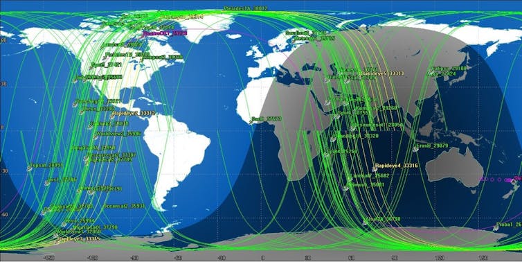
Satellites provide the vantage point necessary to monitor large areas of ocean. Spacecraft carrying synthetic aperture radar (SAR) can provide high-quality images with resolution down to a metre, regardless of the weather. But the relatively small number of spacecraft equipped with SAR, and the dawn-to-dusk orbits which most occupy, also limit the times of day when they can provide coverage.
To offer comprehensive monitoring at sea, we need to bring together different types of imaging, including radar and photographic images in the human-visible wavelength. This is often overlooked for maritime purposes due to the effects of cloud, rain, and darkness that limit its use. But there are enough satellites with the capability that could provide excellent coverage.
Detail and coverage
The two key requirements for effective monitoring are high spatial resolution (good detail) and a large field of view (wide area). One tends to come at the expense of the other, so that a device – whether it is a camera, satellite or radar – capable of detecting small vessels will usually only be able to scan an area a few tens of kilometres wide, making it both unlikely that the search area of interest has been recorded and rendering subsequent searches very slow.
But the situation is changing. The number of imagers is growing rapidly. In our recently published study , we identified 54 satellites carrying 85 sensors which offer useful resolution and could be accessed commercially (excluding military surveillance spacecraft). Companies such as PlanetLabs are in the process of launching many more.
While each satellite’s imaging device generates an image track only 10-100km across, the motion of the satellite as it orbits the Earth effectively “scans” that track so that the image is narrow in one dimension but circles the world in the other. With orbital periods of around 90 minutes, one satellite makes around 16 passes over the daylit hemisphere every day. The combined imaging work of all these satellites now make a significant contribution to our awareness of maritime traffic.
Image early, image often
Imagery used in search-and-rescue operations is usually taken after the target is lost. In the case of the Niña which disappeared off the coast of New Zealand, eight days elapsed between last radio contact and the alarm being raised. For MH370, the search area evolved over periods of weeks. In both cases, ocean currents carry evidence away from the accident site, while debris disperses and sinks, making it more difficult to identify by satellite.
It would be far better to have an archive of recent, regularly updated images so that the recent history of a location over a period of several days can be examined. This could offer evidence of the vessel’s course or state, or pick up on areas of fresh, concentrated debris.
Making the best of what we have
Satellites with visible wavelength cameras are generally used for gathering images of land. What if satellite operators could generate revenue by taking images of the oceans? The limited resources on satellites mean that it isn’t generally possible to constantly take images, to store that data and transmit it all in the next available contact with the ground (which may be some time after an image is acquired). As it is, it’s not possible to create a global maritime monitoring system of this kind without purpose-built spacecraft with bigger data storage and more frequent contact with ground stations to download it.
But it is possible to monitor high-priority areas of heavy traffic, protected fisheries and security-critical regions, with co-operation between operators of existing spacecraft (for which there are precedents such as George Clooney’s Satellite Sentinel Project , which uses satellites to gather evidence of atrocities and war crimes), and incentives, perhaps involving maritime insurance companies.
Retrieving hundreds of gigabytes of data a day from satellites requires a new approach to ground stations. One solution may be to “crowdsource”: to create a network of stations operated by small institutions, universities and individuals to spread the burden of downloading data and increasing the periods during which data can be recorded and transmitted.
There are groups working on automated vessel-detection algorithms – and crowdsourcing also has a role here, such as TomNod , for example, which asked members of the public to help inspect images online in the search for Niña. How much more effective could search and rescue be if the power of crowdsourcing was applied to each stage of data acquisition, storage and processing, combined with high-quality images taken around the time the vessel was lost?
- satellite tracking
- Missing aircraft
- Search and Rescue
- Maritime security
Professor of Indigenous Cultural and Creative Industries (Identified)
Communications Director
Associate Director, Post-Award, RGCF
University Relations Manager
2024 Vice-Chancellor's Research Fellowships
- Electric Cars
- Electric Bikes
- Electric Boats
- EV Conversions
- Electric Flight
- Electric Transport
- Hydrogen Fuel Cell
- Readers’ Questions

Electric Candela hydrofoil boat sets world record by crossing Baltic Sea
- September 16, 2024
- 2 minute read
- Joshua S. Hill
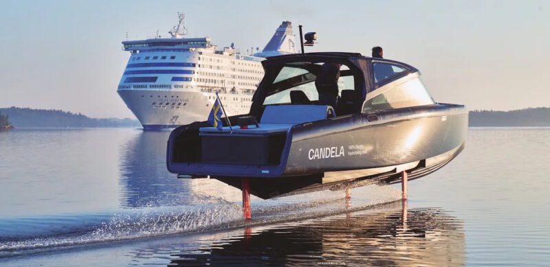
An all-electric hydrofoiling boat from Swedish company Candela has set two new world records by travelling between Stockholm and the Finnish autonomous region of Åland, marking the first time an electric boat has crossed the Baltic Sea.
Candela, which has developed a range of electric hydrofoil boats and ships, wanted to demonstrate that “that zero-emission sea travel is not only possible today, but that foiling electric ships and boats are so much cheaper to operate than fossil-fuelled vessels.”
The record-breaking journey was undertaken in the Candela C-8, a €330,000 ($A544,500) leisure craft, equipped with a battery from technology partner Polestar.
The journey covered 150 nautical miles from the port of Frihamn in Stockholm, Sweden, to Mariehamn, the capital and largest town of the Åland Islands, an autonomous region of Finland, with a charging stop in Kapellskär.
While charging along the trip was made mostly with existing charging infrastructure, a 40kW Kempower Movable Charger was needed in Kapellskär.
Leaving from Frihamn at 6am, the Candela C-8 made it to Mariehamn by lunchtime, and returned to Frihamn the same day.
YouTube : https://www.youtube.com/watch?v=6hFoRF_Q0CA
“The disadvantage of electric boats has been their short range, due to traditional boat hulls consuming so much energy,” said Gustav Hasselskog , the company’s CEO and founder.
“With our hydrofoil technology, we combine high speed and range, but you get so many other benefits. Flying over the Åland Sea in total silence and without slamming was absolutely magical.”
A gasoline-powered chase boat of similar size accompanied the Candela C-8 on the journey and had to be refuelled for a cost of €750, or around $A1,230. For comparison, the Candela C-8 consumed 213 kWh of electricity, at a cost of about €40-50 (around $A66-83).
“We actually had range anxiety, but not for the Candela,” said Gustav Hasselskog.
“The irony is that the photographer’s gasoline-powered chase boat had to refuel six times during the trip, while we only charged three times.
“We’re talking about 95% lower operating costs,” concluded Hasselskog. “This is a revolution that makes waterborne transöport competitive with land transport in terms of costs, which we will now demonstrate in public transport in Stockholm.”

Joshua S. Hill is a Melbourne-based journalist who has been writing about climate change, clean technology, and electric vehicles for over 15 years. He has been reporting on electric vehicles and clean technologies for Renew Economy and The Driven since 2012. His preferred mode of transport is his feet.
We are definitely in an age of disruption, as much as the bashers, critics and cynics like to deny it. Amazing, 1/25th the cost of their ICE partner boat! And quieter, cleaner and calmer too boot!
Google informs me a litre of diesel is € 1.668, so that trip would have used ~450 litres of diesel, or 4,500 kWh. That’s shockingly inefficient.
Input your search keywords and press Enter.
Sean 'Diddy' Combs arrested by federal agents in New York

Sean “Diddy” Combs was arrested Monday, the U.S. Attorney’s Office in New York City said.
Combs was arrested at the Park Hyatt hotel on West 57th Street, a representative said. He was caught off-guard by the apprehension, according to a person familiar with the situation, who added he had been living at the hotel for several weeks.
U.S. Attorney Damian Williams confirmed in a statement that on Monday evening, federal agents arrested Combs based on a sealed indictment filed by the Southern District of New York.
“We expect to move to unseal the indictment in the morning and will have more to say at that time,” Williams said.

Combs’ attorney Marc Agnifilo expressed disappointment in a statement. He said Combs, 54, had been cooperative with the investigation and “voluntarily relocated to New York last week in anticipation of these charges.”“Sean ‘Diddy’ Combs is a music icon, self-made entrepreneur, loving family man, and proven philanthropist who has spent the last 30 years building an empire, adoring his children, and working to uplift the Black community,” the statement said. “He is an imperfect person but he is not a criminal.”
“These are the acts of an innocent man with nothing to hide, and he looks forward to clearing his name in court,” it added.
It was not immediately clear on what charges Combs, the rapper-turned-music mogul, was arrested. Combs has faced a wave of lawsuits — one as recent as last week — accusing him of sexual assault and misconduct since November, when former girlfriend Casandra Ventura sued him in federal court, accusing him of years of physical and sexual abuse.
Ventura, who is best known by her stage name, Cassie, was once signed to Combs’ Bad Boy record label. The two settled her lawsuit a day after it was filed, without disclosing the terms of the settlement. An attorney for Combs said the settlement was not an acknowledgment of wrongdoing. He previously denied the allegations.

Since then, a number of others have sued, including Dawn Richard , who alleged that he groped and threatened her when he employed her from 2005 to 2012 and that she witnessed him brutally beat Ventura. Combs has vehemently denied the accusations in the lawsuits, saying they were “sickening allegations” from people looking for “a quick payday.” But in May, after CNN released hotel video of Combs kicking, punching and throwing Ventura on the floor in a hallway in Los Angeles in 2016, he apologized in a video on Instagram in which he said that his behavior was “inexcusable” and that he had sought therapy. The video was later removed from his page.
Richard, who was a member of the girl group Danity Kane, which Combs formed on the MTV reality competition “Making the Band,” and later the group Diddy — Dirty Money, sued Combs last week.
An attorney said Combs was “shocked and disappointed” by Richard’s lawsuit, which, like Ventura’s complaint, depicts him as controlling and violent.
Ventura’s lawsuit included allegations of sex trafficking. She alleged that he frequently beat her, that he forced her to engage in sex acts with male prostitutes — drug-fueled encounters Combs referred to as “freak offs” and sometimes recorded — and that in 2018, as she was trying to end their relationship, he forced his way into her home and raped her.
Richard said in her suit that she attended “drug-fueled parties,” where guests were required to surrender their phones. She also said she witnessed what she believed were inebriated underage girls being sexually violated by Combs and his guests.

In March, federal investigators searched Combs’ homes in Miami and Los Angeles. Investigators interviewed several people in relation to allegations of sex trafficking, sexual assault and the solicitation and distribution of illegal narcotics and firearms, a source familiar with the investigation told NBC News in March.
The warrant to search Combs’ properties came from the Southern District of New York, NBC News has reported.
Combs, who has also gone by such names as Puffy, Puff Daddy and Love, founded Bad Boy in the early 1990s. He is regarded as a trailblazer of hip-hop, fashion and media, having created the Sean John clothing line and launched the Revolt TV channel, which he sold his stake in over the summer .
Rodney “Lil Rod” Jones, a producer on Combs’ most recent album, alleged in a lawsuit in February that Combs made unwanted sexual contact, forced him to hire prostitutes and pressured him to participate in sex acts with them. Jones said he lived and traveled with Combs from September 2022 to November 2023, during which time he recorded hours of video and audio of Combs, his staff and others “engaging in serious illegal activity.”
His attorneys, Rodney S. Diggs and Tyrone Blackburn, who are also representing other Combs accusers, said Combs’ “long awaited arrest” was “an important step towards justice for all of Mr. Combs’ victims.”
“We leave the criminal aspect of this case in the hands of the people and justice system,” they said Monday night. “As for the civil cases, we await our time for the facts to reveal themselves and seek the justice our clients deserve. We also anticipate more victims coming forward. We knew this was coming. The evidence is very clear and it was only a matter of time.”
After the hotel video of Combs assaulting Ventura was published, Howard University cut ties with him . In June, the school rescinded an honorary degree it awarded him and disbanded a scholarship program in his name. The same month, Combs honored a request from New York Mayor Eric Adams and returned his key to the city .
This month, Combs listed his home in Los Angeles that was raided in March for $61.5 million.
Chloe Melas is an entertainment correspondent for NBC News.
Julia Ainsley is the homeland security correspondent for NBC News and covers the Department of Homeland Security for the NBC News Investigative Unit.
Janelle Griffith is a national reporter for NBC News focusing on issues of race and policing.
Doha Madani is a senior breaking news reporter for NBC News. Pronouns: she/her.
A boat with dozens of migrants rips apart in the English Channel off France, killing 12
Officials say a boat carrying migrants has ripped apart in the English Channel as they tried to reach Britain from northern France, and 12 are dead
BOULOGNE-SUR-MER, France — A boat carrying migrants ripped apart in the English Channel as they attempted to reach Britain from northern France on Tuesday, plunging dozens into the treacherous waterway and leaving 12 dead, authorities said.
Most of the victims were believed to be women, some under 18, and many of the passengers didn’t have life preservers, officials said, with one calling it the deadliest migrant accident in the channel this year.
“Unfortunately, the bottom of the boat ripped open,” said Olivier Barbarin, mayor of Le Portel near Boulogne-sur-Mer, where a first aid post was set up to treat victims. “If people don’t know how to swim in the agitated waters ... it can go very quickly.”
Europe’s increasingly strict asylum rules , growing xenophobia and hostile treatment of migrants have been pushing them north. Before Tuesday’s accident, at least 30 migrants had died or gone missing while trying to cross to the U.K. this year, according to the International Organization for Migration.
Rescuers pulled a total of 65 people from the English Channel on Tuesday in a search that lasted more than four hours, according to Lt. Etienne Baggio, a spokesman for the French agency that oversees the stretch of sea where the boat ripped apart. Doctors confirmed 12 died, he said.
Another 12 people were hospitalized, and two were in very serious conditions, authorities said.
Adam Beernaert, director of the Civil Protection authority, whose personnel looks after rescued migrants once they reach land, said the people his team attended Tuesday were traumatized. “What needs to be said is that they shouldn’t cross,” Beernaert told the AP. “The sea is not easy. Weather conditions change all the time.”
Baggio called it the deadliest migrant boat tragedy in the English Channel this year. In July, four migrants died while attempting the crossing on an inflatable boat that capsized and punctured. Five others, including a child, died in another attempt in April. And five dead were recovered from the seas or found washed up along a beach after a migrant boat ran into difficulties in the dark and winter cold of January.
Many of those aboard the vessel that broke up in the English Channel on Tuesday didn’t have life vests, Baggio said. He said the boat was an inflatable. Three helicopters, a plane, two fishing boats and more than six other vessels were involved in the rescue operation.
In another sea tragedy Tuesday involving migrants seeking a better life in Europe, a boat carrying migrants capsized in the Mediterranean off the Libyan coast, leaving one person dead and 22 missing, Libyan authorities said.
The agency overseeing the rescue operation in the English Channel said the boat got into difficulty off Gris-Nez point between Boulogne-sur-Mer and the port of Calais further north. Sea temperatures off northern France were around 20 degrees C, or about 68 F.
Interior Minister Gerald Darmanin went to Boulogne-sur-Mer to meet those involved in handling what he described as the “terrible shipwreck.” He said the boat was frail and small — less than 7 meters (23 feet) long — and that smugglers are packing more and more people aboard such vessels. Most of the people on the boat were believed to be from Eritrea, and most of the victims were women, he said.
Last week, the leaders of France and the U.K. agreed to deepen cooperation on illegal migration in the channel.
“We absolutely must — and this is a very important point — re-establish special relations with our British friends,” Darmanin said on Tuesday. He later told the AP that to successfully tackle smuggling networks, immigration legislation between the U.K. and France should be harmonized.
“It has now been 30 years that these problems remain, and it is absolutely necessary that we find solutions,” said Barbarin, the mayor of Le Portel.
U.K. Home Secretary Yvette Cooper called it “a horrifying and deeply tragic incident” and paid tribute to French rescuers “who undoubtedly saved many lives, but sadly could not save everyone.”
“The gangs behind this appalling and callous trade in human lives have been cramming more and more people onto increasingly unseaworthy dinghies, and sending them out into the Channel even in very poor weather,” she said.
“They do not care about anything but the profits they make, and that is why — as well as mourning the awful loss of life — the work to dismantle these dangerous and criminal smuggler gangs and to strengthen border security is so vital and must proceed apace.”
At least 2,109 migrants have tried to cross the English Channel on small boats in the past seven days, according to U.K. Home Office data updated Tuesday. The data includes people found in the channel or on arrival.
Associated Press writer Lorne Cook in Brussels contributed.
Follow AP coverage of migration at https://apnews.com/hub/migration

Sir Keir Starmer seeks urgent fix over small boat crossings during controversial Italy trip
It may have been a controversial trip to Italy, but the new prime minister needs to find a way to stop deaths in the Channel.
By Darren McCaffrey, political correspondent in Rome
Monday 16 September 2024 15:31, UK

"The return of British pragmatism" - these were the words from the prime minister's press conference on Monday.
Sir Keir Starmer was in Rome to learn lessons from the Italians on migration, unapologetically trying to understand how Italy had achieved a 60% drop in Mediterranean small boat crossings over the past year.
But this visit was also controversial.
Politics live: PM announces new Italian investment
Because, even amid the pomp of a red carpet welcome and warm optics, it is important to remember that this is an issue that has brought two very different prime ministers from opposite ends of the political spectrum together.
Some at home, even within Labour ranks, have voiced concerns about the new prime minister taking advice from Giorgia Meloni's right-wing government.

But for Sir Keir, the argument is that illegal migration can only be stopped with the type of European cooperation he's trying to achieve here in Italy.
And so his defence is that he, or Britain, was being pragmatic - something the country has prided itself on in the past.
However, he was far from clear on whether the UK was now about to adapt some of those controversial policies.
There was agreement on trying to prevent people migrating in the first place, though not many would disagree with that position.

Keep up with all the latest news from the UK and around the world by following Sky News
Whatever the specifics, what is notable is that for Sir Keir this has to be about more than just international cooperation.
With the worst year on record for deaths in the English Channel so far, it's a mission that has become increasingly urgent.
Related Topics
- Migrant crossings
- Sir Keir Starmer
COMMENTS
MarineTraffic Live Ships Map. Discover information and vessel positions for vessels around the world. Search the MarineTraffic ships database of more than 550000 active and decommissioned vessels. Search for popular ships globally. Find locations of ports and ships using the near Real Time ships map. View vessel details and ship photos.
VesselFinder is a FREE AIS vessel tracking web site. VesselFinder displays real time ship positions and marine traffic detected by global AIS network.
Using AIS watch boats, cruise ships and other vessels across the world in real time. Welcome to Ship Finder, a marine traffic web app designed to track live vessel activity from across the world's seas and oceans developed by Pinkfroot. Showing you up to the minute ship tracking data broadcast straight from vessels equipped with AIS ...
MarineTraffic: Global Ship Tracking Intelligence | AIS Marine Traffic
Cover your Area. My Ship Tracking is a FREE REALTIME AIS vessel finder tracking service. With this vessel tracker you can monitor ship positions, vessel tracking, ship tracking, vessel position, vessels traffic, port activity in realtime map.
Find out information and vessel positions for vessels around the globe. Search ships in our database of more than 80,000 active and decommissioned vessels. ... - 80,000 Sea & River Going Ships - 17,000 Ports & Marinas * - 1,400 Cruise Ports * - 1,370 Sea Airports * - 1,000 Shipyards * - 100 Regional Maps - 100 Top Superyachts - 79 Tall Ships ...
YACHT NAME, Length x Width - Owner's Name. 1. QUINTESSENTIALLY ONE, 220 x 20 m - Company "Quintessentially". 2. AZZAM, 180 x 20 m - Khalifa bin Zayed Al Nahyan. 3. ECLIPSE, 163.5 x 22 m - Roman Abramovich. 4. DUBAI, 162 x 22 m - Mohammed bin Rashid Al Maktoum.
FleetMon is AIS map maritime tracker of ships at sea. Locate current position of cargo, military, container, cruise, tanker and fishing vessels on a live map
Now you are ready to start using: My Fleets. Group vessels to monitor movement. My Notifications. Get notified when changes occur. Voyage History. Get detailed records of past movements & events. MarineTraffic is the world's most popular online service for vessel tracking.
Satellite AIS. monitor the global picture of the world maritime traffic. Unlimited global coverage. Access to undelayed Satellite position data for any ship in the world. Unlimited number of tracked ships. No limits оn the number of tracked ships via Satellite and Terrestrial AIS network. 24 hours 10 USD 1 month 109 USD 1 year 1099 USD.
On the ship location website, one can track 80,000 sea and river-going vessels, know the status of 17,000 ports and marinas, 1400 cruise ports, 1000 shipyards and much more. It is designed for ship owners, managers, logistics companies and agencies. Even individuals can use it for ship tracking. The website has three useful maritime tools-
iPad. iPhone. Description. MarineTraffic displays near real-time positions of ships and yachts worldwide. Using the largest network of land-based AIS receivers, the app covers most major ports and shipping routes. • View VESSELS ON THE LIVE MAP, search for ships, boats and seaports and see what's near you!
TRULY GLOBAL COVERAGE THROUGH TERRESTRIAL AND SATELLITE AIS. We provide multilingual support from four continents to ensure we are well positioned to install and maintain our AIS antennas in all commercial ports. We own and operate our global network of AIS antennas, meaning we can provide optimal data security, scope, reliability and quality.
Charter crewed yachts online - From big luxurious motor boats to smaller sailing catamarans, you find all you need to charter a crewed yacht on BoatsAtSea.com. Our charter experts will help you make your dream vacation come true. We have more than 25 years of experience and will get you the best deals possible.
Explore the free nautical chart of OpenSeaMap, with weather, sea marks, harbours, sport and more features. Download for offline use.
The Superyacht Directory. The Superyacht Directory is the world's largest database of private luxury yachts, with over 12,000 megayachts listed. It's the most authoritative place to find everything you need to know about superyachts - including new builds, historic vessels and the most famous boats of all time.
Ship radar is a map showing the movement of ships in the seas and oceans. Ship tracking and current position on the water. Location at sea and identification of AIS. Details of over 600,000 marine units (ships, ports, lighthouses) Check the movement of ships in the largest ports of the world, where ships sail every few minutes.
Malaysian Navy's KD Pendekar Partially Submerged After Leak in Johor: All 39 Crew Rescued. The Royal Malaysian Navy's (TLDM) KD Pendekar, a vessel with 45 years of service, experienced a critical incident this week, resulting in the ship being partially submerged off the coast of Johor. The incident occurred around noon, approximately two ...
Track Ships Worldwide In This Live Ship Tracker. Track a specific ship live by searching for it by name below or by selecting it from the ship line options below. Tracking a specific ship will give you additional details like the ship's current location, recent track, speed, course, next port destination, estimated time of arrival (ETA) and more.
Best Multipurpose Stern: Bering B165. Turkish boatbuilder Bering Yachts revealed details of its new 162-foot flagship explorer yacht, the B165, at the Dubai International Boat Show in March. The ...
CruiseMapper provides free cruise tracking, current ship positions, itinerary schedules, deck plans, cabins, accidents and incidents ('cruise minus') reports, cruise news
There are great unknowns at sea: planes and boats go missing. Illegal fishing and piracy are easy to conduct - and small vessels can smuggle powerful weapons and dangerous individuals.
An all-electric hydrofoiling boat from Swedish company Candela has set two new world records by travelling between Stockholm and the Finnish autonomous region of Åland, marking the first time an electric boat has crossed the Baltic Sea. Candela, which has developed a range of electric hydrofoil ...
ABOARD A BOAT IN THE STRAIT OF GIBRALTAR — From the surface, the azure waters seem calm and inviting in this narrow patch where the Atlantic Ocean meets the Mediterranean Sea. Spain's arid ...
Sean "Diddy" Combs was arrested Monday, the U.S. Attorney's Office in New York City said. Combs was arrested at the Park Hyatt hotel on West 57th Street, a representative said. He was caught ...
In another sea tragedy Tuesday involving migrants seeking a better life in Europe, a boat carrying migrants capsized in the Mediterranean off the Libyan coast, leaving one person dead and 22 ...
Sir Keir Starmer seeks urgent fix over small boat crossings during controversial Italy trip. It may have been a controversial trip to Italy, but the new prime minister needs to find a way to stop ...